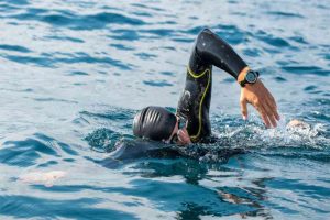
Suunto Traverse Alpha is designed to venture off the beaten track with peace of mind. Are you an adventurer or a fan of outdoor activities (hiking, mountaineering, trekking, etc.) and looking for a tool to record your routes, find your way around and never get lost? Then this GPS & GLONASS connected watch is made for you.
Robust and reliable, the Suunto Traverse combines many features to venture off the beaten track with confidence. Equipped with many tools (GPS, altimeter, barometer, compass, thermometer, weather trend, etc.) and a real-time route recording system allowing you to retrace your steps or be guided towards an objective, Suunto Traverse will be your ally for successful outings.
Explicitly designed for adventurers looking to get off the beaten track, fans of outdoor activities, or even nature lovers, the Suunto Traverse combines elegance, robustness, precision, reliability, ease of use, and advanced navigation features for allowing you to go out in peace, without ever getting lost. The Traverse is not the successor of the Ambit 3, but rather an Ambit 3 revised and simplified for practical use and adapted to the most significant number.
This watch has many sensors and useful navigation tools to find your way around, navigate, and record your routes. Combined with a simple topographic map, you can go anywhere.
[amazon fields=”B01DNSDBDS” value=”thumb” image_size=”large” ]
The Traverse not only allows you to save your routes for later viewing on a map and analyze all associated data but also to define, from the Suunto Movescount app, your ways and points of interest (POIs) or download those of Suunto users to display them on your watch then and perform them in the field. It displays in real-time on its screen the trace of your route and all the navigation data useful for your exit. It even allows you to retrace your steps if necessary, thanks to its “little thumb” function. It can also display a route stored on the watch or direct you to points of interest you set in the watch.
Distance traveled, speed, rate of climb, altitude, heading, position, atmospheric pressure, weather trend, sunrise and sunset times, temperature, strength, and altitude graphs: you have all the information you need for your exploration. The Traverse also has a compass and alerts you in the event of a thunderstorm. Waterproof, can use it underwater up to 100 meters!
The icing on the cake, the Finnish firm has provided an activity tracker for this model, which counts the number of your daily steps and the calories expended, which it displays in the form of a graph over the week and the year. An excellent way to motivate yourself to move during the week!
The Watch and Its Components
Packaging
The Traverse is delivered in beautiful packaging, including a proprietary USB cable to connect it to a PC, a very brief start-up guide, and a warranty manual.
Design and Ergonomics
Suunto has bet on quality and beautiful design for this model assembled by hand in its factory in Finland. Its mineral crystal dial and stainless steel bezel associated with a pretty bracelet give it a beautiful look that allows it to be worn daily, even if the case may seem a little big on small wrists (5cm in diameter).
Robust construction with its steel bezel protecting the dial and its case in the lightweight composite material is resistant to shocks and extreme temperatures (-20 ° C to +60 ° C and down to -30 ° C for storage).
Unlike Ambit watches, Suunto offers a very flexible and comfortable silicone strap for the Traverse, which comes in 4 colors: black, white, amber, and graphite. The watch is comfortable to wear, and it is hardly felt on the wrist despite its 80 grams (or 9 g less than the Ambit 3) and its 16 millimeters thick.
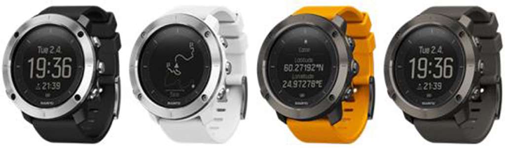
The Traverse is available in 4 colors: black, white, amber, and graphite.
Screen
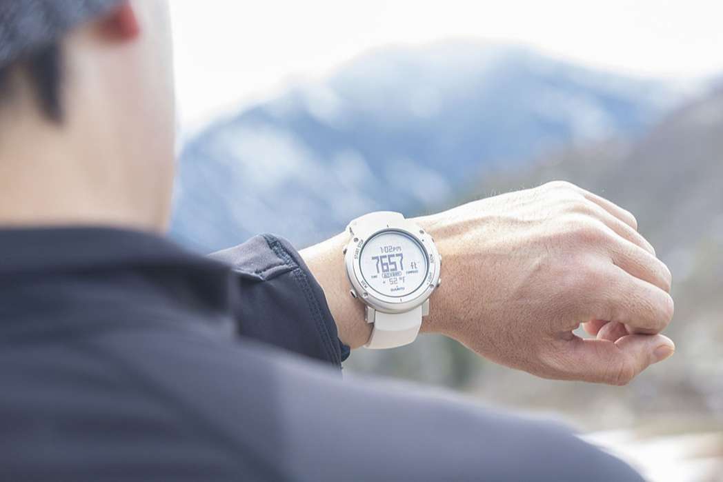
The Suunto Traverse display is a large 128×128 pixel liquid crystal display with up to 3 display lines. It is possible to invert the screen color (display on a black background).
The watch has a programmable intensity backlight to read data when it is dark or at night.
In “watch” mode, the Traverse displays an impressive amount of useful information that can also find in “recording” or “navigation” mode. We describe this data in the next section.
GPS sensor: ultra-fast hooking and GLONASS reception
The GPS chip is located in the bezel of the watch. The search for satellites is ultra-fast thanks to a program integrated into the watch calculating their position. Regular updating of the watch is necessary to ensure this speed. During our tests, the attachment was always done in less than a minute. Suunto has integrated the search for Russian satellites into its watch (GLONASS system or “Global Navigation Satellite System,” a satellite positioning system of Soviet origin). This function adds some consumption to the battery, but it can be disabled. With GLONASS, around twice as many satellites are available and, therefore, fewer stalls in the areas covered (buildings, forest) and, therefore, more reliable.
Barometer (Alti-Baro pressure sensor)
The Traverse is equipped with a pressure sensor (Alti-Baro) located on the back of the watch. It displays atmospheric pressure, predicts weather trends, and can be used in altitude measurement (see below). We detail these functions in the next section (main features).
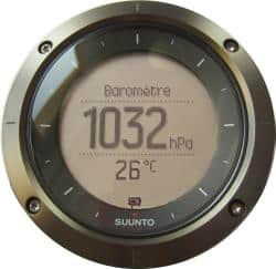
It should note that Suunto’s software is smart enough to limit calculation errors (altitude, vertical speed, etc.) linked to changes in atmospheric pressure. Below 3 km/h, the watch considers that the changes in atmospheric pressure detected by the barometer are linked to unstable weather and not to the upward movement of the user. So the altitude and the height difference do not change. It is these little software details that make a big difference with a low-end watch.
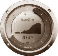
Altimeter
The altimeter makes it possible to determine the altitude and deduce from that place the difference in height covered and the vertical speed of movement. Three distinct methods can measure the altitude:
- From the atmospheric sensor (barometric altitude): the advantage of this method is that it does not depend on the GPS signal, which is practical in sheltered areas (dense forest, caves, buildings, etc.) or if you want to save battery by disabling the use of GPS. Calibration is, however, necessary: it will be required to indicate to the watch the altitude of the place where one is located for which associates the current pressure with the height of the site.
- For good accuracy, this calibration should be repeated every day, particularly in the event of a significant change in atmospheric pressure (difference in weather).
- From GPS (GPS altitude): this method makes it possible to obtain good measurement accuracy, provided that the area where you are located is not covered. In the case of a weak GPS signal, the altitude accuracy will be less.
By combining GPS and barometer (FusedAlti system): optimal precision and reliability are obtained wherever you are.
For greater precision, we recommend that you activate the FusedAlti function.
Compass
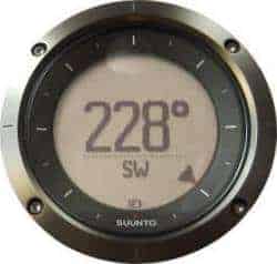
La Traverse has a digital compass indicating magnetic North, a useful tool for finding your bearings from a topographic map. The inclination is automatically corrected, i.e., the compass remains reliable even if the watch is not horizontal. It is also possible to adjust the declination (the difference between magnetic North and Geographic North)
The compass uses GPS and an accelerometer. The disadvantage is that it mobilizes the accelerometer and prevents the counting of the number of steps during the recording of a route or navigation. Too bad.
Battery Life
Suunto has opted for a powerful battery for its Traverse watch and announces an autonomy of 14 days in watch mode and 10 to 100 hours in GPS tracking and navigation mode (depending on the GPS recording frequency: 1s, 5s, or 60s).
You should know that GPS consumes a lot of battery. For trekking trips over several days, you will need to decrease the GPS recording frequency (or turn off the GPS if you do not need it) for maximum autonomy but less precision in the route and navigation. You can also activate GLONASS only when required (Suunto warns that enabling GLONASS increases battery consumption).
First Use
The start-up and installation of the application dedicated to watching data (Movescount) are very simple and fast. You will need to activate the watch by pressing a button, enter some parameters (age, gender, weight, language, unit system), recharge it via the USB cable, install the application on your PC or smartphone from the site www.movescount.com/connect, and finally create an account. Each time you connect the watch to your PC (USB cable) or your smartphone (Bluetooth), the Movescount application starts automatically to read the data from the watch and possibly update its software.
You will find complete instructions and explanatory videos on the Suunto website: www.suunto.com/support.
Settings
The settings and personalization of the watch are done directly from the watch or via the Movescount application. Should do only compass and altimeter calibrations directly from the watch.
Suunto allows you to define a watch usage profile according to the type of activity practiced (hiking, mountaineering, etc.) by favoring the display either of the altitude (for mountain sports, for example) or of the atmospheric pressure (for sea trips, for example). According to the user’s movements, there is also an automatic profile that adapts according to the profile of the route, passing from one profile to another.
Shortcut Buttons
For more efficient use, Suunto has programmed each button on the Traverse to activate the main functions: start/stop a recording, display the main menu or the menu corresponding to the active task, activate the flashlight, lock / unlock buttons, recording a point of interest (POI). Everything is done to make life as easy as possible for the user.
Sporting Activities
The Traverse is programmed in Hiking mode by default, but it is possible to define up to 5 activities in the watch. Programming is done from the Movescount application, which offers more than 70 events. The content of displays, recording frequency, GPS verification frequency, etc., can be configured for each selected activity. Note that the watch does not know how to transition between activities automatically. It is, therefore, not suitable for the practice of triathlon, for example.
The Main Functionalities
“Watch” mode: useful data for everyday use or to prepare for your outing.
In “watch” mode, i.e., outside of navigation, the watch displays four types of a display comprising, on the same screen, 2 to 3 information: a fixed primary data and various information displayed. Scroll by pressing a button.
- Date and time of day (fixed), seconds, the number of steps, battery charge indicator, sunrise and sunset times, weather trend (variation in atmospheric pressure).
- Altitude or atmospheric pressure (fixed), temperature, sunrise and sunset, altitude or atmospheric pressure, the graph of pressure or height over the last 12 or 24 hours.
- Compass
- Activity report (number of steps and calories expended during the day, an average of the number of steps, and graph of the number of steps over seven days and the year). See below.
You can alternate the displays by merely pressing a button (a button to change screens and a button to scroll through the data within a screen)
La Traverse offers an alarm clock function (beep and/or vibration)
Data available in navigation or recording mode
Display screens can be programmed for each activity from the Movescount app. In addition to the above data (watch function), the watch can display the following data:
- Distance traveled
- Instantaneous speed, average speed, immediate pace, average pace
- Altitude, height difference (uphill and downhill), vertical speed
- Temperature
- Sea level pressure
- Track (track of the route traveled) and points of interest (POIs)
- Calories expended
- Stopwatch
- Heart rate, average heart rate (with heart rate belt not included)
Navigation is intuitive and straightforward, although it may take some time to get used to the buttons and their function at first.
Route recording and analysis: take full control of your outing
The Traverse allows you to record the precise coordinates of your route directly in the watch and display the way on its screen, to view all the data and statistics recorded in real-time, and, at the end of the route, to transfer and analyze all this data on your PC or smartphone and even share your ways with the community.
When you start your activity, a long press of a button is enough to start recording. The watch allows you to choose the operation of your choice if you have programmed several (by default, the hiking activity is used). The search for satellites begins.
Once found, you can go for it! It is possible to force recording without waiting for the end of the satellite search, but it is better to wait until the search is finished for good accuracy. To speed up this step, we recommend that you regularly update your watch by connecting it to a PC.

Depending on the settings you have made, ride data is recorded every 1, 5, or 60 seconds. For an outing of more than 10 hours, you will need to limit yourself to 5 or even 60 seconds to save the battery unless you have a portable battery to charge your watch.
As you progress, your route is displayed on the screen. You can thus visualize your movements and even use this path to retrace your steps (see the “little thumb” function detailed below). The watch’s scale adjusts to fit the track completely into the screen, but it is also possible to zoom this track around your position.
At any time, you can access all the data and statistics recorded (distance traveled, speed, average speed, pace, average pace, altitude, rate of climb, vertical drop covered in ascent and descent, atmospheric pressure, compass, weather trend, temperature, GPS position, number of steps taken, heart rate (while wearing an abdominal belt)).
You can also start navigation (see below) on a route saved in your watch (log or route downloaded from your PC or the Suunto community) and thus follow this route. For example, suppose you set off on a mountain trail that later joins a route saved in your watch: all you need to do is launch navigation to view that new route and follow its trail. The watch then displays your current track (in dotted lines) and the recorded route in solid lines. All you have to do is go to this new course and then follow the track on your watch.
Once your tour is complete, all you need to do is connect your watch to your PC or smartphone to transfer the data and analyze it. We will see this later in this article.
The watch can also automatically pause when you stop. If you don’t want to worry about stopping recording during long pauses, a handy function is at the risk of forgetting to restart it.
So-Called Return Path Function (Petit Poucet)
The “Petit Poucet” function gives you real-time track of your route in the form of a record on the watch screen. So you can hike without ever worrying about getting lost. At any time, you can decide to retrace your steps by merely following the trail.
This function is efficient and useful, especially since it is possible to zoom the track for greater precision.
Return Direction (trackback)
Another great feature of the Traverse is the back steering (or trackback) feature. When you activate this function, the watch indicates, with an arrow, the direction to follow as the crow flies to find your starting point.
However, this function has two drawbacks that must take into account:
- When activated, the recording of the route starts again at 0, as if starting a new record. All course data seems lost (track, distance, etc.). Once the trip is over, and the trip data is analyzed, the entire route has been recorded. On the other hand, the trip data recorded before the feedback function activation are lost and are not taken into account in the statistics (distance traveled, etc.).
- If you make two trips during the day, the watch remembers the first trip’s starting point. So if you use the return function on the second exit, the return direction will tell you the starting point of the early departure.
It can also improve the function. Guidance to the points of interest (POIs) saved in the watch is exact (including the distance remaining to be traveled, the difference in altitude, etc.). One could imagine the same precision for the return direction function.
Planning and navigation along a saved route
Suunto Traverse helps you navigate along a planned route. All you have to do is download a route saved in the Movescount application to the watch and start navigation. The track shows you the way to follow and all the route data, including any POIs (points of interest). All you have to do is follow the track displayed on the screen.
You can upload your routes (those that you have saved yourself) or those of the community. You can also create your routes from a map (see our section, The interface). This efficient option allows you to prepare your outing at home, precisely define the circuit and the POIs you want to explore (in theory, because we have not managed to program them on the Traverse, see our section The interface).
Points of interest (POIs): precise recording and guidance
One of Suunto Traverse’s main advantages is its ability to guide you with high precision to POIs (points of interest) saved in your watch or that you have collected during your trip or a previous route.
POIs are positioned (GPS coordinates), indicating a landmark or curiosity on your route. For example, a waterfall, an aesthetic point of view, a monument. In short, any aspect of interest to record or see. We can easily imagine memorizing the coordinates of a place in a big city that we are visiting to return there later in the day or know where it is on a map.
Suunto Traverse can store up to 250 POIs in memory. You can save a POI at the touch of a button. Using a less linear combination, you can also define the type of POI from a long list offered by the watch (campsite, monument, cave, etc.).
To navigate to a saved POI, select it, and follow the on-screen instructions. The watch shows you the direction to follow, the distance separating you from the point of interest, the difference in altitude between your position and that of the location to reach, and even an estimate of the time it will take you to achieve it!
Weather Functions
The Traverse has been well thought out for nature fans and offers everything you need for an adventure.
- Barometry: the barometer continually shows you the air pressure. It is also used to estimate altitude without GPS.
- Weather trend: an arrow indicates the direction of the atmospheric pressure (stable, decreasing, or increasing), making it possible to predict a possible weather change.
- Storm alarm: in the event of a sharp pressure drop, an alert warns you of the risk of a thunderstorm (the signal can be deactivated).
- Sunrise and sunset times: The times of sunrise, sunset, and dawn and dusk are shown. This function requires the use of GPS.
- Temperature: the watch continuously displays and records the heat on the case (skin side). For a reliable measurement, it is, of course, necessary to remove the watch. Thus, we can know the temperature of the mountain lake where we bathed or see how far the thermometer has dropped during the night of bivouac.
- Tide information: this information is available from the Movescount app. You, therefore, need a PC or a smartphone to know them during a sea trip.
Activity Monitoring
Suunto offers a minimalist activity tracker showing on the watch the number of steps taken and a summary for the week and the year.
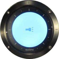
Flashlight
The Finnish brand has planned everything by integrating a “flashlight” function into its watch, activated by a simple long press on the backlight button. The light is obtained by activating the backlighting at its maximum intensity on the white screen background. This gives a bluish light that is certainly not very powerful but sufficient to illuminate the inside of a tent or a bag vaguely.
Heart rate Measurement
The Traverse incorporates a heart rate monitor that indicates your heart rate and calculates your calories burned more accurately. To work, you will need to purchase a Suunto heart rate monitor (Smart Sensor).
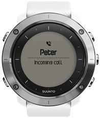
Mobile notifications (calls and SMS transfers)
Convenient if you hike or run with a smartphone, the Traverse notifies you of your incoming calls and SMS.
Other useful functions
The Suunto Traverse is waterproof up to 100 meters. It can, therefore, be used for swimming or diving. It also offers a stopwatch function and a countdown function.
Good to know
You can consult the user guide here.
Interface
Movescount is a sports community and a platform available on PC and smartphones. It allows you to personalize your watch, analyze your routes, track your progress via a sports log, create your routes, upload them to your watch, create training plans, download, and even create your applications to run on the watch!
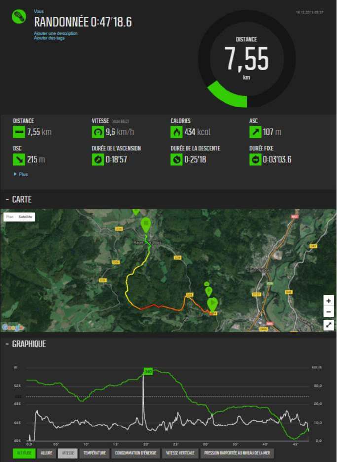
The interface is quite user-friendly and intuitive. A dashboard provides a global view of the statistics (distance traveled, total time, calories burned, cumulative height difference).
A large counter displays the distance traveled for each outing and a table of results: distance, average speed, altitude difference (ascent and descent), duration of ascent and descent, duration. The route traveled is displayed on a Google map (map or satellite view). A graph is used to display the various data recorded (pace, altitude, speed, temperature, calories burned, vertical speed, pressure referred to sea level).
You can combine several curves on the same graph and thus make detailed analyzes of its performance. By selecting a data type, the circuit drawn on the map displays colors representing this data’s values at each point of the course. We can, therefore, at a glance, assess the highlights of the outing.
It is possible, from the graph, to select a part of the route to display this section on the map and obtain all the data associated with this section.
Training programs
Do you want to improve your form, lose weight, or even progress in jogging while staying motivated? Nothing could be more comfortable with training programs! The Movescount app allows you to build your applications (weekly calendar, type of activity, distance, difficulty, frequency, etc.) or download those already offered on the site (Suunto or community programs). Then it’s up to you to follow your schedule.
Itinerary planning
What could be better than preparing for your hike at home! By planning your circuit, the points to visit, and estimating the duration and the difficulty, you will leave with peace of mind, entirely in control of your outing.
Movescount allows you to create your routes by drawing them directly on a map in the application and then uploading them to the watch. Better, the users will be able to precisely trace the circuit starting from a few points that you will have indicated to it by following the roads and even the forest paths recorded in its maps.
In theory, it is possible to program POIs, but we did not find this option on Movescount. It is quite possible to program waypoints, but the Traverse does not recognize them. To date (date of publication of this article), this seems to be an anomaly to correct.
When preparing your route, you can use the Movescount application tools to determine the distance to be covered and the altitude difference.
Turn your route into a 3D movie!
Suunto has created a tool to visualize your route and its critical data on a 3-dimensional map. It is possible to add photos to the animation. Guaranteed effect for your friends!
And if you are interested in 3D movies or virtual reality, know that there are ultra-light sports cameras capable of shooting 360 degrees, such as the Garmin VIRB 360, which also films in ultra-high definition (4K).
Sharing with other platforms
The Traverse is compatible with many applications, including Diveboard, Diviac, MapMyFitness, MXActivityMover, Strava, TrainingPeaks, Mbody, Preva Networked Fitness, SportsTracker.
Exporting data from a PC
Your rides’ data are stored in your Movescount account and can be exported in the following formats: GPX, KML (Google Earth), XLSX (Excel), FIT, TCX.
Using a smartphone
With the smartphone application, you can use your data anywhere, even in a bivouac in the mountains. You need to bring a mini backup battery or a solar charger with you to ensure autonomy.
Our Opinion
The Suunto Traverse is a watch very suitable for hiking, trekking, or mountaineering. It was designed for this mainly, and it is complete for a controlled and serene outing without being complex to use. Although it can use it for other sports such as jogging, cycling, or swimming, if you are a demanding athlete, it will be better to point you towards an Ambit 3, which offers functions designed especially for these activities. The Traverse has been deliberately simplified for optimal comfort of use for the outdoors.

Thus, it is less sophisticated than the Ambit. It is aimed at the highest number, and its shortened buttons make it practical even if it takes some adaptation time to memorize the various functions and make good use of the watch. It is better for a user not accustomed to Suunto watches to plan a few outings to master it well before venturing off the beaten track, which is reasonable given the many functions available.
On the navigation side, we appreciate the precision of the GPS and the inclusion of the GLONASS system, and also the fact that we can deactivate the GPS to save battery. The Petit Poucet track in real-time is a good thing to retrace your steps or to know if you are still on the right track when following a predefined route. Even if the watch does not display a map, we can easily find our way, particularly thanks to the precision offered by the zoom of the track. A topographic map remains an essential tool despite everything.
The “return route” function is also useful for finding your starting point (provided you have not taken an outing earlier in the day, see our comments above). The only downside is that we lost the distance and time data when activating it as if we were recording a new route!
We particularly appreciated the navigation to points of interest (POIs): extremely precise, and it allows you to find any location even without a map. Impressive.
Regarding the activity tracker, it remains very succinct. Only the number of steps is counted, and the statistics do not appear in the Movescount application.
On the application side, Movescount is both user-friendly and easy to use. Using data and creating routes is intuitive. The summary display gives a consolidated view of statistics for the year. It does not seem possible to have a monthly breakdown, which is a shame.
Overall, we recommend this watch rather than an Ambit for outdoor type outings (hiking, mountaineering, trail, trekking).
Where to buy the Suunto Traverse Watch?
You will find the Suunto Traverse in specialist stores or on the internet. We recommend the following partners who offer it at preferential rates.
[amazon box=”B01DNSDBDS” description=”SUUNTO Traverse Alpha – SS022469000″]